


refuge de l' alpe

emoreau
User
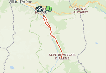

Length
11.5 km

Max alt
2091 m

Uphill gradient
457 m
Km-Effort
17.6 km

Min alt
1668 m

Downhill gradient
468 m
Boucle
Yes
Creation date :
2023-06-03 06:37:29.611
Updated on :
2023-06-12 13:12:50.692
4h27
Difficulty : Difficult

FREE GPS app for hiking
 SityTrail
IGN / Geographical institutes
SityTrail Plus
The world is yours!
About
Trail Walking of 11.5 km to be discovered at Provence-Alpes-Côte d'Azur, Hautes-Alpes, Villar-d'Arêne. This trail is proposed by emoreau.
Positioning
Country:
France
Region :
Provence-Alpes-Côte d'Azur
Department/Province :
Hautes-Alpes
Municipality :
Villar-d'Arêne
Location:
Unknown
Start:(Dec)
Start:(UTM)
292394 ; 4989764 (32T) N.
Comments