


Chateau de Bridoire

JMCMoreau
User
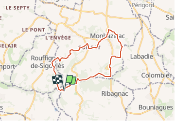

Length
13.9 km

Max alt
179 m

Uphill gradient
221 m
Km-Effort
16.9 km

Min alt
87 m

Downhill gradient
222 m
Boucle
Yes
Creation date :
2023-06-12 15:52:09.219
Updated on :
2023-06-12 15:53:54.301
3h45
Difficulty : Medium

FREE GPS app for hiking
 SityTrail
IGN / Geographical institutes
SityTrail Plus
The world is yours!
About
Trail Walking of 13.9 km to be discovered at New Aquitaine, Dordogne, Ribagnac. This trail is proposed by JMCMoreau.
Positioning
Country:
France
Region :
New Aquitaine
Department/Province :
Dordogne
Municipality :
Ribagnac
Location:
Unknown
Start:(Dec)
Start:(UTM)
299170 ; 4960207 (31T) N.
Comments
OK merci