Trail Walking Bech - 2023-06-13_20h54m51_Mullerthal_Trail_ExtraTour_C - Photo

2023-06-13_20h54m51_Mullerthal_Trail_ExtraTour_C

© OpenStreetMap contributors
Length
Length
9.3 km
Max alt
Max alt
400 m
Uphill gradient
Uphill gradient
234 m
Km-Effort
Km-Effort  
12.4 km
Min alt
Min alt
304 m
Downhill gradient
Downhill gradient
244 m
Boucle
Boucle
Yes
Creation date :
2023-06-13 18:54:51.53
Updated on :
2023-06-13 18:56:47.784

(0 Reviews)

Walking
Walking
2h49
Difficulty : Medium

Scan this QR Code to open this trail in the SityTrail application

FREE GPS app for hiking

Logo SityTrail SityTrail

IGN / Geographical institutes

Download SityTrail from the App Store Download SityTrail from Google Play

Logo SityTrail SityTrail World

The world is yours!

Download SityTrail from the App Store Download SityTrail from Google Play Download SityTrail on Huawei AppGallery

About

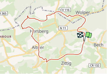
Trail Walking of 9.3 km to be discovered at Unknown, Canton Echternach, Bech. This trail is proposed by mumu.larandonneuse.

Description

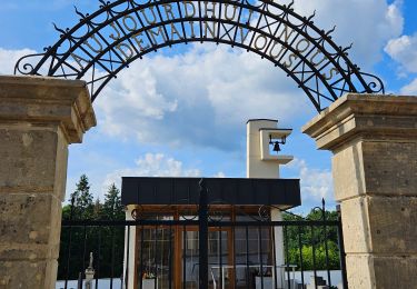
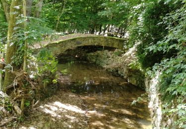
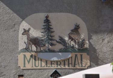
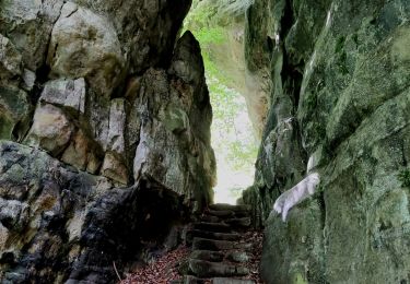
L'ExtraTour C relie les localités de Bech et Altrier avec le Mullerthal Trail. A Bech, vous passez à côté de l’ancienne gare de chemin de fer qui a été transformée en un chalet pour accueillir des groupes. Vous passez ensuite par le Tunnel de Bech qui a une longueur de 300 m et sert en même temps de piste cyclable (attention aux vélos !). La partie entre Bech et Altrier offre de très belles vues sur la vallée. Les attractions sur le chemin sont le Tumulus (tombeau du temps des Romains) et le site naturel de "Bildchen" à Altrier (grand chêne de plus de 1000 ans)
ℹ️ www.mullerthal-trail.lu

Elevation profile

Positioning

Country:
Luxembourg
Region :
Unknown
Department/Province :
Canton Echternach
Municipality :
Bech
Location:
Unknown
Start:(UTM)
309457 ; 5514552 (32U) N.

Trails nearby

Trail Walking Consdorf - 2023-06-19_09h33m43_Sentier_local_-_C6 - Photo
Walking
GUIDE
mumu.larandonneuse

Walking

Medium
(1)
Consdorf, Unknown, Canton Echternach, Luxembourg
5.8 km | 7.3 km-effort
1h 39min
Yes
Trail Walking Consdorf - 2023-06-13_20h43m48_Sentier_local_-_C2 - Photo
Walking
GUIDE
mumu.larandonneuse

Walking

Easy
(1)
Consdorf, Unknown, Canton Echternach, Luxembourg
4.2 km | 5.5 km-effort
1h 15min
Yes
Trail Walking Consdorf - 2023-06-13_20h03m09_Circuit_auto-pdestre_Consdorf_-_Mullerthal - Photo
Walking
GUIDE
mumu.larandonneuse

Walking

Medium
(1)
Consdorf, Unknown, Canton Echternach, Luxembourg
9 km | 12.3 km-effort
2h 48min
Yes
Trail Walking Consdorf - 2023-06-21_17h04m10_Sentier_local_-_C1 (1) - Photo
Walking
GUIDE
mumu.larandonneuse

Walking

Easy
(1)
Consdorf, Unknown, Canton Echternach, Luxembourg
1.9 km | 2.5 km-effort
34min
Yes
Trail Walking Waldbillig - Mullerthal randonnée magnifique - Photo
Walking
Alfredy

Walking

Difficult
(4)
Waldbillig, Unknown, Canton Echternach, Luxembourg
9.3 km | 12.9 km-effort
4h 21min
Yes
Trail Walking Waldbillig - MÜLLERTHAL (Cascades) - Photo
Walking
GerardBouche

Walking

Medium
(1)
Waldbillig, Unknown, Canton Echternach, Luxembourg
10.2 km | 13.7 km-effort
3h 1min
Yes
Trail Other activity Waldbillig - Luxemburg: Mullerthal - Consdorf - Mullerthal - Photo
Other activity
mikeryckmans

Other activity

Very difficult
(3)
Waldbillig, Unknown, Canton Echternach, Luxembourg
11.5 km | 15.4 km-effort
4h 10min
Yes
Trail Walking Waldbillig - 20220525 - Mullertal 11.7 Km - Photo
Walking
GUIDE
pierreh01

Walking

Medium
Waldbillig, Unknown, Canton Echternach, Luxembourg
11.7 km | 15.4 km-effort
4h 31min
Yes
Trail Walking Consdorf - Superbe promenade vers le Kuelscheier   - Photo
Walking
GUIDE+

Walking

Medium
(1)
Consdorf, Unknown, Canton Echternach, Luxembourg
6.6 km | 8.3 km-effort
1h 53min
Yes


Close
My subscriptions