


val d arly croix cartier

anniediot
User
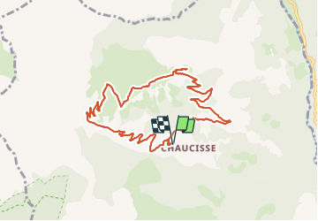

Length
10 km

Max alt
1827 m

Uphill gradient
522 m
Km-Effort
16.9 km

Min alt
1320 m

Downhill gradient
520 m
Boucle
Yes
Creation date :
2023-06-14 06:37:41.906
Updated on :
2023-06-14 13:49:51.801
4h49
Difficulty : Easy

FREE GPS app for hiking
 SityTrail
IGN / Geographical institutes
SityTrail Plus
The world is yours!
About
Trail Walking of 10 km to be discovered at Auvergne-Rhône-Alpes, Savoy, Saint-Nicolas-la-Chapelle. This trail is proposed by anniediot.
Positioning
Country:
France
Region :
Auvergne-Rhône-Alpes
Department/Province :
Savoy
Municipality :
Saint-Nicolas-la-Chapelle
Location:
Unknown
Start:(Dec)
Start:(UTM)
304342 ; 5078024 (32T) N.
Comments