


Le Tour de Reynes

Phidel66
User
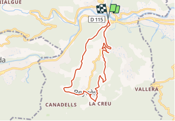

Length
8.1 km

Max alt
338 m

Uphill gradient
284 m
Km-Effort
11.9 km

Min alt
157 m

Downhill gradient
284 m
Boucle
Yes
Creation date :
2023-06-15 13:07:58.618
Updated on :
2023-06-15 13:10:42.308
2h42
Difficulty : Easy

FREE GPS app for hiking
 SityTrail
IGN / Geographical institutes
SityTrail Plus
The world is yours!
About
Trail On foot of 8.1 km to be discovered at Occitania, Pyrénées-Orientales, Reynès. This trail is proposed by Phidel66.
Description
Romarins
Photos

Positioning
Country:
France
Region :
Occitania
Department/Province :
Pyrénées-Orientales
Municipality :
Reynès
Location:
Unknown
Start:(Dec)
Start:(UTM)
476593 ; 4704770 (31T) N.
Comments