Trail Walking Ambleny - Ambleny circuit St Martin  - Photo

Ambleny circuit St Martin

 José800
José800

User

© OpenStreetMap contributors
Length
Length
13.3 km
Max alt
Max alt
144 m
Uphill gradient
Uphill gradient
279 m
Km-Effort
Km-Effort  
17 km
Min alt
Min alt
47 m
Downhill gradient
Downhill gradient
280 m
Boucle
Boucle
Yes
Creation date :
2023-06-15 07:52:40.134
Updated on :
2023-06-15 13:27:35.697

(0 Reviews)

Walking
Walking
3h32
Difficulty : Difficult

Scan this QR Code to open this trail in the SityTrail application

FREE GPS app for hiking

Logo SityTrail SityTrail

IGN / Geographical institutes

Download SityTrail from the App Store Download SityTrail from Google Play

Logo SityTrail SityTrail World

The world is yours!

Download SityTrail from the App Store Download SityTrail from Google Play Download SityTrail on Huawei AppGallery

About

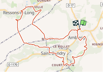
Trail Walking of 13.3 km to be discovered at Hauts-de-France, Aisne, Ambleny. This trail is proposed by José800.

Description

beaux villages , très beau paysages,  forêts,  une superbe randonnée.

Elevation profile

Photos

Positioning

Country:
France
Region :
Hauts-de-France
Department/Province :
Aisne
Municipality :
Ambleny
Location:
Unknown
Start:(UTM)
513357 ; 5469792 (31U) N.

Trails nearby

Trail Walking Ambleny - Les pas Saint-Martin - Photo
Walking
tracegps

Walking

Very difficult
(2)
Ambleny, Hauts-de-France, Aisne, France
12.2 km | 16 km-effort
3h 0min
Yes
Trail Walking Osly-Courtil - La balade de Saint-Médard - Photo
Walking
tracegps

Walking

Medium
(1)
Osly-Courtil, Hauts-de-France, Aisne, France
12.2 km | 14.2 km-effort
3h 45min
Yes
Trail Walking Vic-sur-Aisne - vic sur aisne - Photo
Walking
bohynm

Walking

Medium
(1)
Vic-sur-Aisne, Hauts-de-France, Aisne, France
13.7 km | 16.5 km-effort
3h 12min
Yes
Trail Walking Fontenoy - Châteaux et coteaux - Photo
Walking
tracegps

Walking

Medium
Fontenoy, Hauts-de-France, Aisne, France
9.8 km | 11.6 km-effort
2h 0min
Yes
Trail Walking Laversine - La promenade de Gabrielle - Photo
Walking
tracegps

Walking

Medium
Laversine, Hauts-de-France, Aisne, France
7.9 km | 10 km-effort
2h 15min
Yes
Trail Walking Saconin-et-Breuil - Le vallon de la mémoire - Photo
Walking
tracegps

Walking

Medium
Saconin-et-Breuil, Hauts-de-France, Aisne, France
5.7 km | 7.6 km-effort
1h 30min
Yes
Trail Walking Pernant - Le roc de Pernant - Photo
Walking
tracegps

Walking

Very difficult
Pernant, Hauts-de-France, Aisne, France
7.2 km | 9.7 km-effort
2h 0min
Yes
Trail Walking Berny-Rivière - Le bois de Chapeaumont - Photo
Walking
tracegps

Walking

Medium
Berny-Rivière, Hauts-de-France, Aisne, France
5.8 km | 7.5 km-effort
2h 0min
Yes
Trail Walking Vic-sur-Aisne - Sur les traces des Poilus - Photo
Walking
tracegps

Walking

Very difficult
(1)
Vic-sur-Aisne, Hauts-de-France, Aisne, France
14.1 km | 17.1 km-effort
4h 30min
Yes


Close
My subscriptions