


fillols taurinya

JeanPierreNancy
User
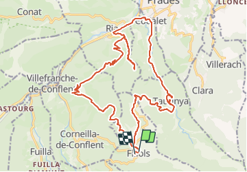

Length
28 km

Max alt
793 m

Uphill gradient
665 m
Km-Effort
37 km

Min alt
361 m

Downhill gradient
679 m
Boucle
Yes
Creation date :
2023-06-16 13:23:15.959
Updated on :
2023-06-16 17:23:29.632
2h10
Difficulty : Difficult

FREE GPS app for hiking
 SityTrail
IGN / Geographical institutes
SityTrail Plus
The world is yours!
About
Trail Mountain bike of 28 km to be discovered at Occitania, Pyrénées-Orientales, Fillols. This trail is proposed by JeanPierreNancy.
Photos

Positioning
Country:
France
Region :
Occitania
Department/Province :
Pyrénées-Orientales
Municipality :
Fillols
Location:
Unknown
Start:(Dec)
Start:(UTM)
451621 ; 4712352 (31T) N.
Comments