


Chante beau merle st Paul

viaul
User GUIDE

Length
18.3 km

Max alt
234 m

Uphill gradient
296 m
Km-Effort
22 km

Min alt
152 m

Downhill gradient
297 m
Boucle
Yes
Creation date :
2023-06-18 05:39:19.0
Updated on :
2023-06-19 13:28:00.398
4h08
Difficulty : Easy

FREE GPS app for hiking
 SityTrail
IGN / Geographical institutes
SityTrail Plus
The world is yours!
About
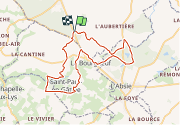
Trail Walking of 18.3 km to be discovered at New Aquitaine, Deux-Sèvres, Moncoutant-sur-Sèvre. This trail is proposed by viaul.
Positioning
Country:
France
Region :
New Aquitaine
Department/Province :
Deux-Sèvres
Municipality :
Moncoutant-sur-Sèvre
Location:
La Chapelle-Saint-Étienne
Start:(Dec)
Start:(UTM)
682889 ; 5169920 (30T) N.
Comments