


aiguebelette

JPS73
User

Length
15 km

Max alt
1034 m

Uphill gradient
583 m
Km-Effort
23 km

Min alt
411 m

Downhill gradient
733 m
Boucle
No
Creation date :
2023-06-20 08:01:25.514
Updated on :
2023-06-20 14:28:41.474
4h19
Difficulty : Very difficult

FREE GPS app for hiking
 SityTrail
IGN / Geographical institutes
SityTrail Plus
The world is yours!
About
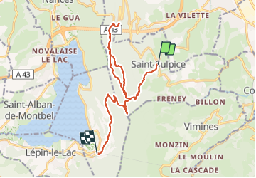
Trail Walking of 15 km to be discovered at Auvergne-Rhône-Alpes, Savoy, Saint-Sulpice. This trail is proposed by JPS73.
Positioning
Country:
France
Region :
Auvergne-Rhône-Alpes
Department/Province :
Savoy
Municipality :
Saint-Sulpice
Location:
Unknown
Start:(Dec)
Start:(UTM)
721961 ; 5049930 (31T) N.
Comments