


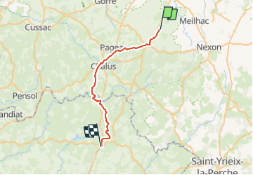
Flavignac à La Coquille

BOUMA
User

Length
33 km

Max alt
467 m

Uphill gradient
604 m
Km-Effort
41 km

Min alt
305 m

Downhill gradient
624 m
Boucle
No
Creation date :
2022-04-23 06:44:30.934
Updated on :
2023-06-22 09:19:24.117
7h11
Difficulty : Difficult

FREE GPS app for hiking
 SityTrail
IGN / Geographical institutes
SityTrail Plus
The world is yours!
About
Trail Nordic walking of 33 km to be discovered at New Aquitaine, Haute-Vienne, Flavignac. This trail is proposed by BOUMA.
Positioning
Country:
France
Region :
New Aquitaine
Department/Province :
Haute-Vienne
Municipality :
Flavignac
Location:
Unknown
Start:(Dec)
Start:(UTM)
351534 ; 5062846 (31T) N.
Comments