


refuge de la dent parrachée

psesjs
User
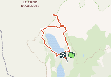

Length
8 km

Max alt
2505 m

Uphill gradient
485 m
Km-Effort
14.5 km

Min alt
2024 m

Downhill gradient
484 m
Boucle
Yes
Creation date :
2023-06-26 07:33:45.959
Updated on :
2023-06-29 10:32:41.068
2h58
Difficulty : Medium

FREE GPS app for hiking
 SityTrail
IGN / Geographical institutes
SityTrail Plus
The world is yours!
About
Trail Walking of 8 km to be discovered at Auvergne-Rhône-Alpes, Savoy, Aussois. This trail is proposed by psesjs.
Positioning
Country:
France
Region :
Auvergne-Rhône-Alpes
Department/Province :
Savoy
Municipality :
Aussois
Location:
Unknown
Start:(Dec)
Start:(UTM)
321630 ; 5013389 (32T) N.
Comments