


collet refuge Vallonbrun

psesjs
User
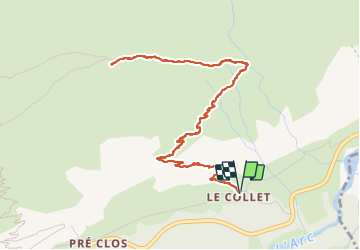

Length
6.6 km

Max alt
2294 m

Uphill gradient
551 m
Km-Effort
13.9 km

Min alt
1756 m

Downhill gradient
551 m
Boucle
Yes
Creation date :
2023-06-29 07:30:24.252
Updated on :
2023-06-29 10:32:45.961
2h14
Difficulty : Medium

FREE GPS app for hiking
 SityTrail
IGN / Geographical institutes
SityTrail Plus
The world is yours!
About
Trail Walking of 6.6 km to be discovered at Auvergne-Rhône-Alpes, Savoy, Val-Cenis. This trail is proposed by psesjs.
Positioning
Country:
France
Region :
Auvergne-Rhône-Alpes
Department/Province :
Savoy
Municipality :
Val-Cenis
Location:
Lanslevillard
Start:(Dec)
Start:(UTM)
339165 ; 5018606 (32T) N.
Comments