


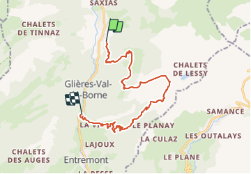
Lac de lessy en boucle

Chantal74
User

Length
14.4 km

Max alt
1862 m

Uphill gradient
1137 m
Km-Effort
30 km

Min alt
751 m

Downhill gradient
1138 m
Boucle
No
Creation date :
2023-07-04 17:18:40.855
Updated on :
2023-07-04 17:21:04.417
6h43
Difficulty : Very difficult

FREE GPS app for hiking
 SityTrail
IGN / Geographical institutes
SityTrail Plus
The world is yours!
About
Trail Walking of 14.4 km to be discovered at Auvergne-Rhône-Alpes, Upper Savoy, Glières-Val-de-Borne. This trail is proposed by Chantal74.
Description
Montée au lac de Lessy par le Paradis, et descente par les chalets de Mayze, puis Entremont, et retour en stop jusqu'au Petit Bornand, car la route nationale est dangereuse à pied
Positioning
Country:
France
Region :
Auvergne-Rhône-Alpes
Department/Province :
Upper Savoy
Municipality :
Glières-Val-de-Borne
Location:
Le Petit-Bornand-les-Glières
Start:(Dec)
Start:(UTM)
298537 ; 5097253 (32T) N.
Comments