


Pic de Charance et crêtes depuis Les Serrigues

Clo0413
User
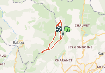

Length
10.3 km

Max alt
1869 m

Uphill gradient
816 m
Km-Effort
21 km

Min alt
1359 m

Downhill gradient
810 m
Boucle
Yes
Creation date :
2023-07-06 06:33:34.796
Updated on :
2023-07-07 07:33:47.127
3h45
Difficulty : Medium

FREE GPS app for hiking
 SityTrail
IGN / Geographical institutes
SityTrail Plus
The world is yours!
About
Trail Walking of 10.3 km to be discovered at Provence-Alpes-Côte d'Azur, Hautes-Alpes, Gap. This trail is proposed by Clo0413.
Positioning
Country:
France
Region :
Provence-Alpes-Côte d'Azur
Department/Province :
Hautes-Alpes
Municipality :
Gap
Location:
Gap
Start:(Dec)
Start:(UTM)
266501 ; 4942288 (32T) N.
Comments