


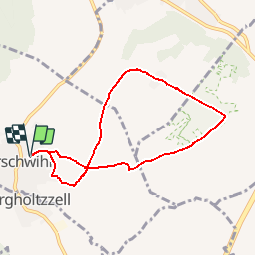
Orschwihr- Bollenberg

regisbodilis
User

Length
7 km

Max alt
331 m

Uphill gradient
142 m
Km-Effort
8.9 km

Min alt
241 m

Downhill gradient
142 m
Boucle
Yes
Creation date :
2014-12-26 00:00:00.0
Updated on :
2014-12-26 00:00:00.0
1h55
Difficulty : Easy

FREE GPS app for hiking
 SityTrail
IGN / Geographical institutes
SityTrail Plus
The world is yours!
About
Trail Walking of 7 km to be discovered at Grand Est, Haut-Rhin, Orschwihr. This trail is proposed by regisbodilis.
Description
Départ église vers Chapelle du Bollenberg - losange vert puis cercle bleu - retour par le vignoble cercle bleu.
Positioning
Country:
France
Region :
Grand Est
Department/Province :
Haut-Rhin
Municipality :
Orschwihr
Location:
Unknown
Start:(Dec)
Start:(UTM)
368191 ; 5310638 (32T) N.
Comments