


t136529032_albignac- 7.2 km

Gpoujade
User
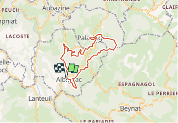

Length
13.8 km

Max alt
534 m

Uphill gradient
430 m
Km-Effort
19.6 km

Min alt
236 m

Downhill gradient
430 m
Boucle
Yes
Creation date :
2023-07-08 06:37:08.0
Updated on :
2024-03-27 11:34:09.697
4h26
Difficulty : Very difficult

FREE GPS app for hiking
 SityTrail
IGN / Geographical institutes
SityTrail Plus
The world is yours!
About
Trail Walking of 13.8 km to be discovered at New Aquitaine, Corrèze, Albignac. This trail is proposed by Gpoujade.
Description
Boucle au départ du bourg d'Albignac
Positioning
Country:
France
Region :
New Aquitaine
Department/Province :
Corrèze
Municipality :
Albignac
Location:
Unknown
Start:(Dec)
Start:(UTM)
396020 ; 4999237 (31T) N.
Comments