


GLIERES: PLATEAU - GAUTARD - NOTRE DAME DES NEIGES

djeepee74
User
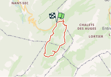

Length
10.6 km

Max alt
1588 m

Uphill gradient
291 m
Km-Effort
14.5 km

Min alt
1377 m

Downhill gradient
289 m
Boucle
Yes
Creation date :
2023-07-09 07:27:11.711
Updated on :
2023-07-09 16:24:34.896
3h17
Difficulty : Easy

FREE GPS app for hiking
 SityTrail
IGN / Geographical institutes
SityTrail Plus
The world is yours!
About
Trail Walking of 10.6 km to be discovered at Auvergne-Rhône-Alpes, Upper Savoy, Fillière. This trail is proposed by djeepee74.
Description
BOUCLE... live du 20230709
Retour monument par "piste de ski de fond".
Photos

Positioning
Country:
France
Region :
Auvergne-Rhône-Alpes
Department/Province :
Upper Savoy
Municipality :
Fillière
Location:
Thorens-Glières
Start:(Dec)
Start:(UTM)
292836 ; 5093428 (32T) N.
Comments