


sardiere

JPS73
User
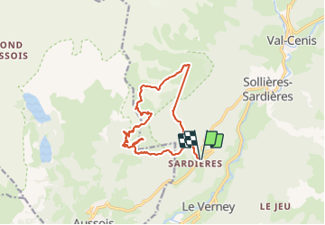

Length
13.7 km

Max alt
2485 m

Uphill gradient
1046 m
Km-Effort
28 km

Min alt
1498 m

Downhill gradient
1046 m
Boucle
Yes
Creation date :
2023-07-04 06:47:55.228
Updated on :
2023-07-11 14:05:07.633
3h45
Difficulty : Very difficult

FREE GPS app for hiking
 SityTrail
IGN / Geographical institutes
SityTrail Plus
The world is yours!
About
Trail Walking of 13.7 km to be discovered at Auvergne-Rhône-Alpes, Savoy, Val-Cenis. This trail is proposed by JPS73.
Positioning
Country:
France
Region :
Auvergne-Rhône-Alpes
Department/Province :
Savoy
Municipality :
Val-Cenis
Location:
Sollières-Sardières
Start:(Dec)
Start:(UTM)
325987 ; 5012531 (32T) N.
Comments