


SityTrail - malmerspach-mésange

JCLUTT
User
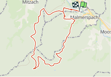

Length
11.5 km

Max alt
774 m

Uphill gradient
567 m
Km-Effort
19.1 km

Min alt
401 m

Downhill gradient
575 m
Boucle
Yes
Creation date :
2023-07-12 07:29:03.956
Updated on :
2023-07-12 07:32:12.182
4h20
Difficulty : Very difficult

FREE GPS app for hiking
 SityTrail
IGN / Geographical institutes
SityTrail Plus
The world is yours!
About
Trail Walking of 11.5 km to be discovered at Grand Est, Haut-Rhin, Saint-Amarin. This trail is proposed by JCLUTT.
Positioning
Country:
France
Region :
Grand Est
Department/Province :
Haut-Rhin
Municipality :
Saint-Amarin
Location:
Unknown
Start:(Dec)
Start:(UTM)
352859 ; 5303440 (32T) N.
Comments