


Vincent run and bike

mapomme
User
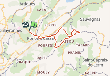

Length
13.5 km

Max alt
192 m

Uphill gradient
213 m
Km-Effort
16.3 km

Min alt
64 m

Downhill gradient
208 m
Boucle
Yes
Creation date :
2014-12-30 00:00:00.0
Updated on :
2014-12-30 00:00:00.0
1h34
Difficulty : Unknown

FREE GPS app for hiking
 SityTrail
IGN / Geographical institutes
SityTrail Plus
The world is yours!
About
Trail Mountain bike of 13.5 km to be discovered at New Aquitaine, Lot-et-Garonne, Pont-du-Casse. This trail is proposed by mapomme.
Positioning
Country:
France
Region :
New Aquitaine
Department/Province :
Lot-et-Garonne
Municipality :
Pont-du-Casse
Location:
Unknown
Start:(Dec)
Start:(UTM)
313956 ; 4900934 (31T) N.
Comments