


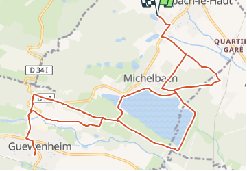
Aspach le Haut - Michrlbach - Guéwenheim et retour comme indiqué

patrickbeyrath
User

Length
15.2 km

Max alt
389 m

Uphill gradient
222 m
Km-Effort
18.2 km

Min alt
304 m

Downhill gradient
222 m
Boucle
Yes
Creation date :
2018-10-13 05:52:52.973
Updated on :
2018-10-13 05:52:52.988
3h56
Difficulty : Easy

FREE GPS app for hiking
 SityTrail
IGN / Geographical institutes
SityTrail Plus
The world is yours!
About
Trail Walking of 15.2 km to be discovered at Grand Est, Haut-Rhin, Aspach-Michelbach. This trail is proposed by patrickbeyrath.
Positioning
Country:
France
Region :
Grand Est
Department/Province :
Haut-Rhin
Municipality :
Aspach-Michelbach
Location:
Aspach-le-Haut
Start:(Dec)
Start:(UTM)
359365 ; 5292896 (32T) N.
Comments