


Ranspach- Markstein- Gomm-20/07- jeudi- cop- copain

chantalwaltzer
User
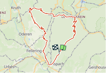

Length
23 km

Max alt
1194 m

Uphill gradient
1134 m
Km-Effort
38 km

Min alt
459 m

Downhill gradient
1130 m
Boucle
Yes
Creation date :
2023-07-20 06:40:36.0
Updated on :
2023-07-20 21:19:43.533
7h39
Difficulty : Unknown

FREE GPS app for hiking
 SityTrail
IGN / Geographical institutes
SityTrail Plus
The world is yours!
About
Trail Walking of 23 km to be discovered at Grand Est, Haut-Rhin, Ranspach. This trail is proposed by chantalwaltzer.
Description
Très bien- A refaire
Positioning
Country:
France
Region :
Grand Est
Department/Province :
Haut-Rhin
Municipality :
Ranspach
Location:
Unknown
Start:(Dec)
Start:(UTM)
351624 ; 5306409 (32T) N.
Comments