


ARAVIS 05

reneperrin
User
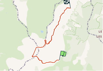

Length
6.5 km

Max alt
2395 m

Uphill gradient
821 m
Km-Effort
17.8 km

Min alt
1479 m

Downhill gradient
917 m
Boucle
No
Creation date :
2023-07-23 06:17:00.319
Updated on :
2025-05-07 11:13:57.537
4h02
Difficulty : Difficult
7h15
Difficulty : Medium

FREE GPS app for hiking
 SityTrail
IGN / Geographical institutes
SityTrail Plus
The world is yours!
About
Trail Walking of 6.5 km to be discovered at Auvergne-Rhône-Alpes, Savoy, Ugine. This trail is proposed by reneperrin.
Description
traversée charvin
Positioning
Country:
France
Region :
Auvergne-Rhône-Alpes
Department/Province :
Savoy
Municipality :
Ugine
Location:
Unknown
Start:(Dec)
Start:(UTM)
300524 ; 5074684 (32T) N.
Comments