


labaroche Evaux

jcschubnel
User
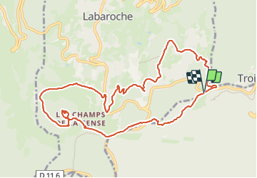

Length
11.4 km

Max alt
922 m

Uphill gradient
336 m
Km-Effort
15.9 km

Min alt
676 m

Downhill gradient
339 m
Boucle
Yes
Creation date :
2023-07-16 12:18:31.46
Updated on :
2023-07-24 09:51:45.424
3h35
Difficulty : Difficult

FREE GPS app for hiking
 SityTrail
IGN / Geographical institutes
SityTrail Plus
The world is yours!
About
Trail Walking of 11.4 km to be discovered at Grand Est, Haut-Rhin, Labaroche. This trail is proposed by jcschubnel.
Positioning
Country:
France
Region :
Grand Est
Department/Province :
Haut-Rhin
Municipality :
Labaroche
Location:
Unknown
Start:(Dec)
Start:(UTM)
367290 ; 5328675 (32U) N.
Comments