Trail Walking Gigny-sur-Saône - G . Gigny sur Saone - Lampagny - Bois de Servelles - Bords de Saone - retour par halte nautique . - Photo

G . Gigny sur Saone - Lampagny - Bois de Servelles - Bords de Saone - retour par halte nautique .

© OpenStreetMap contributors
Length
Length
10.3 km
Max alt
Max alt
184 m
Uphill gradient
Uphill gradient
68 m
Km-Effort
Km-Effort  
11.2 km
Min alt
Min alt
169 m
Downhill gradient
Downhill gradient
69 m
Boucle
Boucle
Yes
Creation date :
2023-07-25 09:11:37.743
Updated on :
2023-07-25 09:14:43.682

(0 Reviews)

Walking
Walking
2h33
Difficulty : Medium

Scan this QR Code to open this trail in the SityTrail application

FREE GPS app for hiking

Logo SityTrail SityTrail

IGN / Geographical institutes

Download SityTrail from the App Store Download SityTrail from Google Play

Logo SityTrail SityTrail World

The world is yours!

Download SityTrail from the App Store Download SityTrail from Google Play Download SityTrail on Huawei AppGallery

About

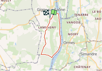
Trail Walking of 10.3 km to be discovered at Bourgogne-Franche-Comté, Saône-et-Loire, Gigny-sur-Saône. This trail is proposed by jeanpaulcheyssac.

Description

Départ : Parking mairie , église à coté chateau d'eau .

Elevation profile

Positioning

Country:
France
Region :
Bourgogne-Franche-Comté
Department/Province :
Saône-et-Loire
Municipality :
Gigny-sur-Saône
Location:
Unknown
Start:(UTM)
648543 ; 5168536 (31T) N.

Trails nearby

Trail Mountain bike Gigny-sur-Saône - De Breurey lès Faverney à Vignieu en VTT- Étape 4/6 - Photo
Mountain bike
tracegps

Mountain bike

Easy
Gigny-sur-Saône, Bourgogne-Franche-Comté, Saône-et-Loire, France
45 km | 49 km-effort
3h 10min
No
Trail On foot Simandre - G . Simandre - Champs des noyers - Champs des Voivres - Bois brules - La Cathenière - Raimbos - Chatenay et retour par le bourg .  - Photo
On foot
jeanpaulcheyssac

On foot

Easy
Simandre, Bourgogne-Franche-Comté, Saône-et-Loire, France
12.1 km | 13.1 km-effort
2h 59min
Yes
Trail Walking Ormes - G . Ormes - Noiry - Bas des prés , bord de Saone - le Port - Le Barrage - Pique nique Simandre et retour par La Tuilerie et le Luminaire . - Photo
Walking
jeanpaulcheyssac

Walking

Medium
Ormes, Bourgogne-Franche-Comté, Saône-et-Loire, France
10.4 km | 11.5 km-effort
2h 36min
Yes
Trail Walking Baudrières - P, Baudrières , Moulin Gay - la Corvée - étang dela Verne - les Mourons et retour  - Photo
Walking
jeanpaulcheyssac

Walking

Medium
Baudrières, Bourgogne-Franche-Comté, Saône-et-Loire, France
8.3 km | 9.4 km-effort
2h 8min
Yes
Trail Walking Simandre - G . Simandre Est  - Photo
Walking
jeanpaulcheyssac

Walking

Medium
Simandre, Bourgogne-Franche-Comté, Saône-et-Loire, France
9.7 km | 10.7 km-effort
2h 25min
Yes
Trail Walking Saint-Cyr - G . St Cyr - Nully et retour  - Photo
Walking
jeanpaulcheyssac

Walking

Medium
(1)
Saint-Cyr, Bourgogne-Franche-Comté, Saône-et-Loire, France
10.1 km | 10.8 km-effort
2h 27min
Yes
Trail Walking Saint-Cyr - st cyr - Photo
Walking
tountouri

Walking

Very easy
Saint-Cyr, Bourgogne-Franche-Comté, Saône-et-Loire, France
11.5 km | 12.1 km-effort
2h 49min
Yes
Trail Walking Gigny-sur-Saône - w-frankrijk-gigny-sur-saone - Photo
Walking
gpstracks

Walking

Very easy
Gigny-sur-Saône, Bourgogne-Franche-Comté, Saône-et-Loire, France
12.2 km | 13.2 km-effort
Unknown
Yes
Trail Walking Gigny-sur-Saône - Gigny - Photo
Walking
PapyChalon

Walking

Very easy
Gigny-sur-Saône, Bourgogne-Franche-Comté, Saône-et-Loire, France
8.8 km | 9.4 km-effort
Unknown
Yes


Close
My subscriptions