


13 km | 20 km-effort

User GUIDE


FREE GPS app for hiking
 SityTrail
IGN / Geographical institutes
SityTrail World
The world is yours!
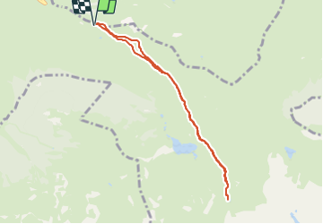
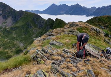
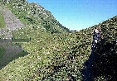
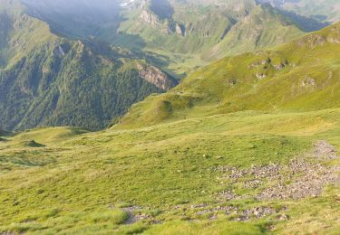
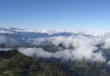
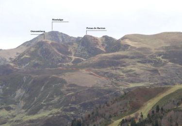
Trail Walking of 7.8 km to be discovered at Occitania, Hautespyrenees, Beaucens. This trail is proposed by marmotte65.
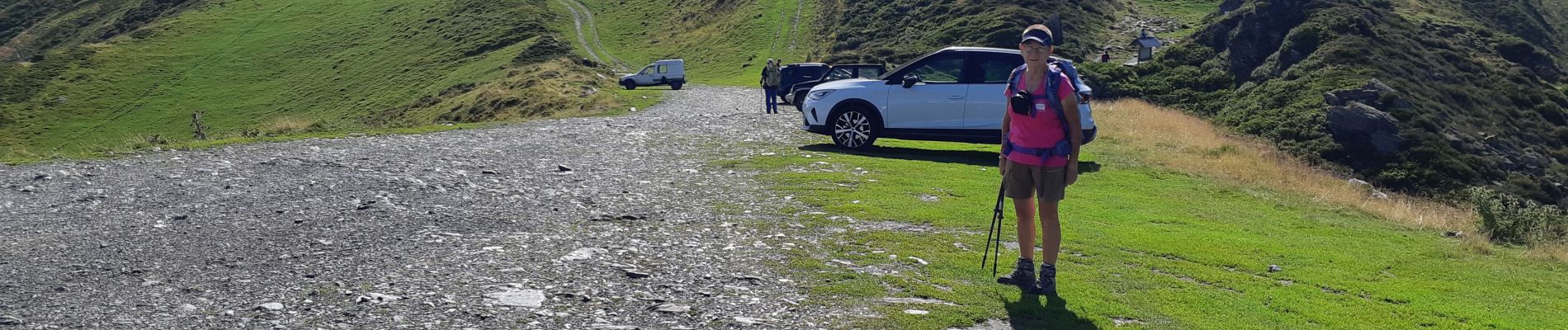
Très belle randonnée au depart du col de la muleta mais malheureusement pas faisable avec un G4 les 200 derniers mètres sont trop technique et représentent un gros risque pour certains marcheurs..... dommage
 "
data-pinterest-text="Pin it"
data-tweet-text="share on twitter"
data-facebook-share-url="https://www.sitytrail.com/en/trails/3750368-beaucens--hautacam-lac-dets-plagnous-x3750368x/?photo=1#lg=1&slide=1"
data-twitter-share-url="https://www.sitytrail.com/en/trails/3750368-beaucens--hautacam-lac-dets-plagnous-x3750368x/?photo=1#lg=1&slide=1"
data-googleplus-share-url="https://www.sitytrail.com/en/trails/3750368-beaucens--hautacam-lac-dets-plagnous-x3750368x/?photo=1#lg=1&slide=1"
data-pinterest-share-url="https://www.sitytrail.com/en/trails/3750368-beaucens--hautacam-lac-dets-plagnous-x3750368x/?photo=1#lg=1&slide=1">
"
data-pinterest-text="Pin it"
data-tweet-text="share on twitter"
data-facebook-share-url="https://www.sitytrail.com/en/trails/3750368-beaucens--hautacam-lac-dets-plagnous-x3750368x/?photo=1#lg=1&slide=1"
data-twitter-share-url="https://www.sitytrail.com/en/trails/3750368-beaucens--hautacam-lac-dets-plagnous-x3750368x/?photo=1#lg=1&slide=1"
data-googleplus-share-url="https://www.sitytrail.com/en/trails/3750368-beaucens--hautacam-lac-dets-plagnous-x3750368x/?photo=1#lg=1&slide=1"
data-pinterest-share-url="https://www.sitytrail.com/en/trails/3750368-beaucens--hautacam-lac-dets-plagnous-x3750368x/?photo=1#lg=1&slide=1">
 "
data-pinterest-text="Pin it"
data-tweet-text="share on twitter"
data-facebook-share-url="https://www.sitytrail.com/en/trails/3750368-beaucens--hautacam-lac-dets-plagnous-x3750368x/?photo=2#lg=1&slide=2"
data-twitter-share-url="https://www.sitytrail.com/en/trails/3750368-beaucens--hautacam-lac-dets-plagnous-x3750368x/?photo=2#lg=1&slide=2"
data-googleplus-share-url="https://www.sitytrail.com/en/trails/3750368-beaucens--hautacam-lac-dets-plagnous-x3750368x/?photo=2#lg=1&slide=2"
data-pinterest-share-url="https://www.sitytrail.com/en/trails/3750368-beaucens--hautacam-lac-dets-plagnous-x3750368x/?photo=2#lg=1&slide=2">
"
data-pinterest-text="Pin it"
data-tweet-text="share on twitter"
data-facebook-share-url="https://www.sitytrail.com/en/trails/3750368-beaucens--hautacam-lac-dets-plagnous-x3750368x/?photo=2#lg=1&slide=2"
data-twitter-share-url="https://www.sitytrail.com/en/trails/3750368-beaucens--hautacam-lac-dets-plagnous-x3750368x/?photo=2#lg=1&slide=2"
data-googleplus-share-url="https://www.sitytrail.com/en/trails/3750368-beaucens--hautacam-lac-dets-plagnous-x3750368x/?photo=2#lg=1&slide=2"
data-pinterest-share-url="https://www.sitytrail.com/en/trails/3750368-beaucens--hautacam-lac-dets-plagnous-x3750368x/?photo=2#lg=1&slide=2">
 "
data-pinterest-text="Pin it"
data-tweet-text="share on twitter"
data-facebook-share-url="https://www.sitytrail.com/en/trails/3750368-beaucens--hautacam-lac-dets-plagnous-x3750368x/?photo=3#lg=1&slide=3"
data-twitter-share-url="https://www.sitytrail.com/en/trails/3750368-beaucens--hautacam-lac-dets-plagnous-x3750368x/?photo=3#lg=1&slide=3"
data-googleplus-share-url="https://www.sitytrail.com/en/trails/3750368-beaucens--hautacam-lac-dets-plagnous-x3750368x/?photo=3#lg=1&slide=3"
data-pinterest-share-url="https://www.sitytrail.com/en/trails/3750368-beaucens--hautacam-lac-dets-plagnous-x3750368x/?photo=3#lg=1&slide=3">
"
data-pinterest-text="Pin it"
data-tweet-text="share on twitter"
data-facebook-share-url="https://www.sitytrail.com/en/trails/3750368-beaucens--hautacam-lac-dets-plagnous-x3750368x/?photo=3#lg=1&slide=3"
data-twitter-share-url="https://www.sitytrail.com/en/trails/3750368-beaucens--hautacam-lac-dets-plagnous-x3750368x/?photo=3#lg=1&slide=3"
data-googleplus-share-url="https://www.sitytrail.com/en/trails/3750368-beaucens--hautacam-lac-dets-plagnous-x3750368x/?photo=3#lg=1&slide=3"
data-pinterest-share-url="https://www.sitytrail.com/en/trails/3750368-beaucens--hautacam-lac-dets-plagnous-x3750368x/?photo=3#lg=1&slide=3">
 "
data-pinterest-text="Pin it"
data-tweet-text="share on twitter"
data-facebook-share-url="https://www.sitytrail.com/en/trails/3750368-beaucens--hautacam-lac-dets-plagnous-x3750368x/?photo=4#lg=1&slide=4"
data-twitter-share-url="https://www.sitytrail.com/en/trails/3750368-beaucens--hautacam-lac-dets-plagnous-x3750368x/?photo=4#lg=1&slide=4"
data-googleplus-share-url="https://www.sitytrail.com/en/trails/3750368-beaucens--hautacam-lac-dets-plagnous-x3750368x/?photo=4#lg=1&slide=4"
data-pinterest-share-url="https://www.sitytrail.com/en/trails/3750368-beaucens--hautacam-lac-dets-plagnous-x3750368x/?photo=4#lg=1&slide=4">
"
data-pinterest-text="Pin it"
data-tweet-text="share on twitter"
data-facebook-share-url="https://www.sitytrail.com/en/trails/3750368-beaucens--hautacam-lac-dets-plagnous-x3750368x/?photo=4#lg=1&slide=4"
data-twitter-share-url="https://www.sitytrail.com/en/trails/3750368-beaucens--hautacam-lac-dets-plagnous-x3750368x/?photo=4#lg=1&slide=4"
data-googleplus-share-url="https://www.sitytrail.com/en/trails/3750368-beaucens--hautacam-lac-dets-plagnous-x3750368x/?photo=4#lg=1&slide=4"
data-pinterest-share-url="https://www.sitytrail.com/en/trails/3750368-beaucens--hautacam-lac-dets-plagnous-x3750368x/?photo=4#lg=1&slide=4">
 "
data-pinterest-text="Pin it"
data-tweet-text="share on twitter"
data-facebook-share-url="https://www.sitytrail.com/en/trails/3750368-beaucens--hautacam-lac-dets-plagnous-x3750368x/?photo=5#lg=1&slide=5"
data-twitter-share-url="https://www.sitytrail.com/en/trails/3750368-beaucens--hautacam-lac-dets-plagnous-x3750368x/?photo=5#lg=1&slide=5"
data-googleplus-share-url="https://www.sitytrail.com/en/trails/3750368-beaucens--hautacam-lac-dets-plagnous-x3750368x/?photo=5#lg=1&slide=5"
data-pinterest-share-url="https://www.sitytrail.com/en/trails/3750368-beaucens--hautacam-lac-dets-plagnous-x3750368x/?photo=5#lg=1&slide=5">
"
data-pinterest-text="Pin it"
data-tweet-text="share on twitter"
data-facebook-share-url="https://www.sitytrail.com/en/trails/3750368-beaucens--hautacam-lac-dets-plagnous-x3750368x/?photo=5#lg=1&slide=5"
data-twitter-share-url="https://www.sitytrail.com/en/trails/3750368-beaucens--hautacam-lac-dets-plagnous-x3750368x/?photo=5#lg=1&slide=5"
data-googleplus-share-url="https://www.sitytrail.com/en/trails/3750368-beaucens--hautacam-lac-dets-plagnous-x3750368x/?photo=5#lg=1&slide=5"
data-pinterest-share-url="https://www.sitytrail.com/en/trails/3750368-beaucens--hautacam-lac-dets-plagnous-x3750368x/?photo=5#lg=1&slide=5">
 "
data-pinterest-text="Pin it"
data-tweet-text="share on twitter"
data-facebook-share-url="https://www.sitytrail.com/en/trails/3750368-beaucens--hautacam-lac-dets-plagnous-x3750368x/?photo=6#lg=1&slide=6"
data-twitter-share-url="https://www.sitytrail.com/en/trails/3750368-beaucens--hautacam-lac-dets-plagnous-x3750368x/?photo=6#lg=1&slide=6"
data-googleplus-share-url="https://www.sitytrail.com/en/trails/3750368-beaucens--hautacam-lac-dets-plagnous-x3750368x/?photo=6#lg=1&slide=6"
data-pinterest-share-url="https://www.sitytrail.com/en/trails/3750368-beaucens--hautacam-lac-dets-plagnous-x3750368x/?photo=6#lg=1&slide=6">
"
data-pinterest-text="Pin it"
data-tweet-text="share on twitter"
data-facebook-share-url="https://www.sitytrail.com/en/trails/3750368-beaucens--hautacam-lac-dets-plagnous-x3750368x/?photo=6#lg=1&slide=6"
data-twitter-share-url="https://www.sitytrail.com/en/trails/3750368-beaucens--hautacam-lac-dets-plagnous-x3750368x/?photo=6#lg=1&slide=6"
data-googleplus-share-url="https://www.sitytrail.com/en/trails/3750368-beaucens--hautacam-lac-dets-plagnous-x3750368x/?photo=6#lg=1&slide=6"
data-pinterest-share-url="https://www.sitytrail.com/en/trails/3750368-beaucens--hautacam-lac-dets-plagnous-x3750368x/?photo=6#lg=1&slide=6">

Walking
Walking
Walking
Walking
Walking
Snowshoes
Walking

Snowshoes
Walking