Trail Walking Goxwiller - Goxwiller-Landsberg-Kapellenhausfelsen-Goxwiller - Photo

Goxwiller-Landsberg-Kapellenhausfelsen-Goxwiller

© OpenStreetMap contributors
Length
Length
17.7 km
Max alt
Max alt
740 m
Uphill gradient
Uphill gradient
619 m
Km-Effort
Km-Effort  
26 km
Min alt
Min alt
166 m
Downhill gradient
Downhill gradient
633 m
Boucle
Boucle
No
Creation date :
2023-07-29 07:31:48.0
Updated on :
2023-07-29 12:27:16.606

(0 Reviews)

Walking
Walking
4h30
Difficulty : Medium

Scan this QR Code to open this trail in the SityTrail application

FREE GPS app for hiking

Logo SityTrail SityTrail

IGN / Geographical institutes

Download SityTrail from the App Store Download SityTrail from Google Play

Logo SityTrail SityTrail World

The world is yours!

Download SityTrail from the App Store Download SityTrail from Google Play Download SityTrail on Huawei AppGallery

About

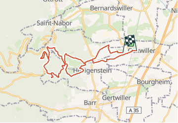
Trail Walking of 17.7 km to be discovered at Grand Est, Bas-Rhin, Goxwiller. This trail is proposed by Silke Roth.

Description

Boucle de randonnée
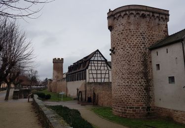
Départ de la gare de Goxwiller
Vignes puis forêt
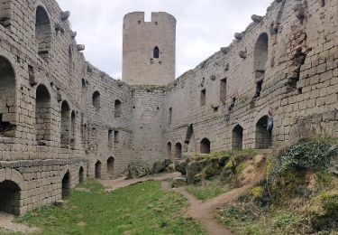
Visite des ruines du château du Lansberg
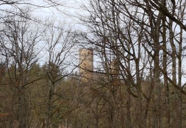
Pause au rocher du Kappellenhausfelsen
Retour à Goxwiller

Elevation profile

Photos

Positioning

Country:
France
Region :
Grand Est
Department/Province :
Bas-Rhin
Municipality :
Goxwiller
Location:
Unknown
Start:(UTM)
386974 ; 5365449 (32U) N.

Trails nearby

Trail Walking Ottrott - Le Mont Sainte-Odile depuis Otrott - Photo
Walking
VacheKiri67

Walking

Medium
(1)
Ottrott, Grand Est, Bas-Rhin, France
13 km | 20 km-effort
6h 18min
Yes
Trail Walking Obernai - Obernai gare - Mont St Odile - Photo
Walking
tracegps

Walking

Difficult
(2)
Obernai, Grand Est, Bas-Rhin, France
20 km | 29 km-effort
5h 0min
Yes
Trail Mountain bike Ottrott - Sainte-Odile East-Face - Photo
Mountain bike
tracegps

Mountain bike

Difficult
(1)
Ottrott, Grand Est, Bas-Rhin, France
24 km | 39 km-effort
3h 0min
Yes
Trail Walking Obernai - sentier des merveilles - Photo
Walking
semila

Walking

Difficult
(1)
Obernai, Grand Est, Bas-Rhin, France
11 km | 16.6 km-effort
4h 8min
Yes
Trail Walking Mittelbergheim - Mittelbergheim - Château du Landsberg - Photo
Walking
tracegps

Walking

Medium
(3)
Mittelbergheim, Grand Est, Bas-Rhin, France
15.4 km | 23 km-effort
5h 0min
Yes
Trail Walking Mittelbergheim - 2023-02-25 Marche Châteaux Andlau Spessbourg Landsberg - Photo
Walking
GUIDE
holtzv

Walking

Very difficult
Mittelbergheim, Grand Est, Bas-Rhin, France
20 km | 30 km-effort
5h 16min
Yes
Trail Walking Andlau - Andlau - château d'Andlau - château du Spesbourg - Photo
Walking
Bart2015

Walking

Easy
Andlau, Grand Est, Bas-Rhin, France
8.6 km | 12.8 km-effort
1h 54min
Yes
Trail Walking Obernai - Obernai - Boersch - Photo
Walking
Bart2015

Walking

Medium
Obernai, Grand Est, Bas-Rhin, France
12.7 km | 15.6 km-effort
2h 20min
Yes
Trail Walking Ottrott - 2022-12-18 Picnic CVA Mt Ste Odile a pied - Photo
Walking
GUIDE
holtzv

Walking

Very difficult
Ottrott, Grand Est, Bas-Rhin, France
15.7 km | 24 km-effort
4h 53min
Yes


Close
My subscriptions