Trail Road bike Aix-en-Provence - Aix Pelissanne 700m+ - Photo
© OpenStreetMap contributors
Length
Length
66 km
Max alt
Max alt
306 m
Uphill gradient
Uphill gradient
696 m
Km-Effort
Km-Effort  
75 km
Min alt
Min alt
59 m
Downhill gradient
Downhill gradient
697 m
Boucle
Boucle
Yes
Creation date :
2023-07-31 13:31:33.754
Updated on :
2023-07-31 13:39:29.165

(0 Reviews)

Road bike
Road bike
4h33
Difficulty : Very difficult

Scan this QR Code to open this trail in the SityTrail application

FREE GPS app for hiking

Logo SityTrail SityTrail

IGN / Geographical institutes

Download SityTrail from the App Store Download SityTrail from Google Play

Logo SityTrail SityTrail World

The world is yours!

Download SityTrail from the App Store Download SityTrail from Google Play Download SityTrail on Huawei AppGallery

About

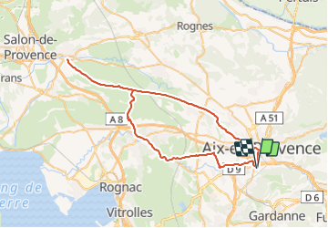
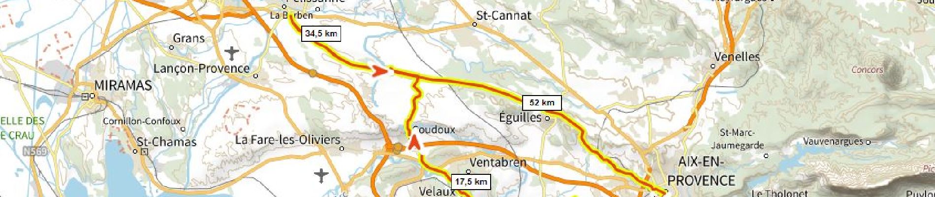
Trail Road bike of 66 km to be discovered at Provence-Alpes-Côte d'Azur, Bouches-du-Rhône, Aix-en-Provence. This trail is proposed by ericberlin.

Description

2023-07-30 avec Hélène.
Tres roulant, calme, cote au dessus de Coudoux

Elevation profile

Photos

Positioning

Country:
France
Region :
Provence-Alpes-Côte d'Azur
Department/Province :
Bouches-du-Rhône
Municipality :
Aix-en-Provence
Location:
Unknown
Start:(UTM)
697327 ; 4820009 (31T) N.

Trails nearby

Trail Walking Aix-en-Provence - Circuit des lacs Zola et Bimont - Aix-en-Provence - Photo
Walking
tracegps

Walking

Medium
(4)
Aix-en-Provence, Provence-Alpes-Côte d'Azur, Bouches-du-Rhône, France
10 km | 13.6 km-effort
2h 30min
Yes
Trail Walking Aix-en-Provence - Aix En Provence - St Beaume - Photo
Walking
Geckos

Walking

Difficult
(1)
Aix-en-Provence, Provence-Alpes-Côte d'Azur, Bouches-du-Rhône, France
65 km | 94 km-effort
19h 29min
No
Trail Walking Aix-en-Provence - Randonnée des barrages Zola et Bimont - Photo
Walking
dudu42

Walking

Medium
Aix-en-Provence, Provence-Alpes-Côte d'Azur, Bouches-du-Rhône, France
10.4 km | 14 km-effort
2h 22min
Yes
Trail Walking Aix-en-Provence - Prés d'Aix, les barrages de Bimont et Zola - Photo
Walking
jll7513

Walking

Easy
Aix-en-Provence, Provence-Alpes-Côte d'Azur, Bouches-du-Rhône, France
10.4 km | 14 km-effort
3h 10min
Yes
Trail Walking Bouc-Bel-Air - bouc cabries par les crêtes  - Photo
Walking
rvdebouc

Walking

Very easy
(1)
Bouc-Bel-Air, Provence-Alpes-Côte d'Azur, Bouches-du-Rhône, France
3.5 km | 4.7 km-effort
47min
Yes
Trail Mountain bike Le Tholonet - Plateau de Bibémus - Aix-en-Provence - Photo
Mountain bike
tracegps

Mountain bike

Medium
Le Tholonet, Provence-Alpes-Côte d'Azur, Bouches-du-Rhône, France
10.6 km | 14 km-effort
1h 0min
Yes
Trail Walking Aix-en-Provence - Pont Arc-Montaiguet-Pont Arc - Photo
Walking
Michael13

Walking

Easy
(1)
Aix-en-Provence, Provence-Alpes-Côte d'Azur, Bouches-du-Rhône, France
5.5 km | 7.7 km-effort
1h 17min
Yes
Trail Walking Aix-en-Provence - Aix-en-Provence Quartier Mazarine  - Photo
Walking
MAUVAGE Patrick

Walking

Easy
Aix-en-Provence, Provence-Alpes-Côte d'Azur, Bouches-du-Rhône, France
3.6 km | 4.1 km-effort
55min
Yes
Trail Walking Aix-en-Provence - Bord de l'Arc, Pont de L'Arc au Pont des 3 Sautets - Photo
Walking
ericberlin

Walking

Medium
Aix-en-Provence, Provence-Alpes-Côte d'Azur, Bouches-du-Rhône, France
6.9 km | 7.6 km-effort
1h 43min
Yes


Close
My subscriptions