Trail Walking Fonters-du-Razès - Boucle Saint Christol  - Photo

Boucle Saint Christol

© OpenStreetMap contributors
Length
Length
12.6 km
Max alt
Max alt
356 m
Uphill gradient
Uphill gradient
275 m
Km-Effort
Km-Effort  
16.3 km
Min alt
Min alt
236 m
Downhill gradient
Downhill gradient
274 m
Boucle
Boucle
Yes
Creation date :
2023-08-01 07:17:16.041
Updated on :
2023-10-07 08:20:44.037

(0 Reviews)

Walking
Walking
2h48
Difficulty : Easy

Scan this QR Code to open this trail in the SityTrail application

FREE GPS app for hiking

Logo SityTrail SityTrail

IGN / Geographical institutes

Download SityTrail from the App Store Download SityTrail from Google Play

Logo SityTrail SityTrail World

The world is yours!

Download SityTrail from the App Store Download SityTrail from Google Play Download SityTrail on Huawei AppGallery

About

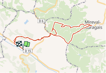
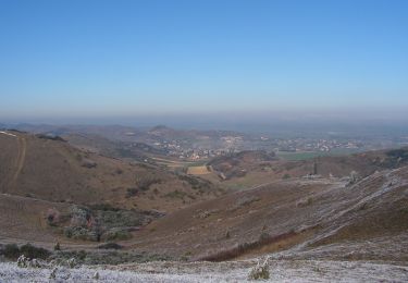
Trail Walking of 12.6 km to be discovered at Occitania, Aude, Fonters-du-Razès. This trail is proposed by Mamilaure.

Description

Se garer au parking de la Chapelle St Christol

Elevation profile

Photos

Positioning

Country:
France
Region :
Occitania
Department/Province :
Aude
Municipality :
Fonters-du-Razès
Location:
Unknown
Start:(UTM)
412110 ; 4788378 (31T) N.

Trails nearby

Trail Mountain bike Villeneuve-la-Comptal - Les collines du pastel - Photo
Mountain bike
tracegps

Mountain bike

Difficult
(1)
Villeneuve-la-Comptal, Occitania, Aude, France
26 km | 33 km-effort
2h 30min
Yes
Trail Walking Laurac - Laurac Fanjeaux - Photo
Walking
tracegps

Walking

Very difficult
(1)
Laurac, Occitania, Aude, France
27 km | 37 km-effort
6h 30min
Yes
Trail Walking Villeneuve-la-Comptal - Villeneuve la Comptal 04 - Photo
Walking
tracegps

Walking

Medium
(1)
Villeneuve-la-Comptal, Occitania, Aude, France
11.2 km | 15 km-effort
2h 30min
Yes
Trail Walking Cazalrenoux - Cazalrenoux  - Photo
Walking
Mamilaure

Walking

Medium
(1)
Cazalrenoux, Occitania, Aude, France
9.8 km | 13.6 km-effort
2h 57min
Yes
Trail Walking Villeneuve-la-Comptal - Villeneuve la Comptal 03 - Photo
Walking
tracegps

Walking

Medium
Villeneuve-la-Comptal, Occitania, Aude, France
14.1 km | 18.9 km-effort
3h 0min
Yes
Trail Walking Villeneuve-la-Comptal - Villeneuve la Comptal 01 - Photo
Walking
tracegps

Walking

Medium
Villeneuve-la-Comptal, Occitania, Aude, France
4.4 km | 6.1 km-effort
1h 0min
Yes
Trail Mountain bike Villeneuve-la-Comptal - Col de Samson - Photo
Mountain bike
tracegps

Mountain bike

Difficult
Villeneuve-la-Comptal, Occitania, Aude, France
14.3 km | 18.8 km-effort
1h 45min
Yes
Trail Walking Villeneuve-la-Comptal - Col de Samson - Photo
Walking
tracegps

Walking

Difficult
Villeneuve-la-Comptal, Occitania, Aude, France
14.3 km | 18.8 km-effort
3h 30min
Yes
Trail Walking Generville - generville - Photo
Walking
ROLLAND Maryse

Walking

Difficult
Generville, Occitania, Aude, France
9.6 km | 13.2 km-effort
2h 56min
Yes


Close
My subscriptions