


280723

JPS73
User
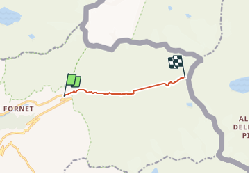

Length
5.4 km

Max alt
2941 m

Uphill gradient
898 m
Km-Effort
14.5 km

Min alt
2055 m

Downhill gradient
21 m
Boucle
No
Creation date :
2023-07-27 06:25:35.75
Updated on :
2023-08-02 09:42:25.709
1h40
Difficulty : Difficult

FREE GPS app for hiking
 SityTrail
IGN / Geographical institutes
SityTrail Plus
The world is yours!
About
Trail Walking of 5.4 km to be discovered at Auvergne-Rhône-Alpes, Savoy, Val-d'Isère. This trail is proposed by JPS73.
Positioning
Country:
France
Region :
Auvergne-Rhône-Alpes
Department/Province :
Savoy
Municipality :
Val-d'Isère
Location:
Unknown
Start:(Dec)
Start:(UTM)
346508 ; 5035328 (32T) N.
Comments