


Planaval / refuge des anges

Stéphane Ruchet
User
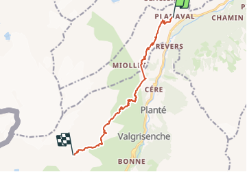

Length
11.1 km

Max alt
2906 m

Uphill gradient
1608 m
Km-Effort
28 km

Min alt
1559 m

Downhill gradient
272 m
Boucle
No
Creation date :
2023-08-02 11:49:21.009
Updated on :
2023-08-02 11:49:35.106
6h22
Difficulty : Very difficult

FREE GPS app for hiking
 SityTrail
IGN / Geographical institutes
SityTrail Plus
The world is yours!
About
Trail Walking of 11.1 km to be discovered at Aosta Valley, Unknown, Arvier. This trail is proposed by Stéphane Ruchet.
Positioning
Country:
Italy
Region :
Aosta Valley
Department/Province :
Unknown
Municipality :
Arvier
Location:
Unknown
Start:(Dec)
Start:(UTM)
350409 ; 5059495 (32T) N.
Comments