


Planaval - Refuge Degli Angeli

i20
User
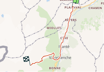

Length
10 km

Max alt
2892 m

Uphill gradient
1453 m
Km-Effort
25 km

Min alt
1512 m

Downhill gradient
139 m
Boucle
No
Creation date :
2023-08-02 18:37:50.636
Updated on :
2023-08-02 18:39:18.373
5h41
Difficulty : Medium

FREE GPS app for hiking
 SityTrail
IGN / Geographical institutes
SityTrail Plus
The world is yours!
About
Trail On foot of 10 km to be discovered at Aosta Valley, Unknown, Arvier. This trail is proposed by i20.
Positioning
Country:
Italy
Region :
Aosta Valley
Department/Province :
Unknown
Municipality :
Arvier
Location:
Unknown
Start:(Dec)
Start:(UTM)
350390 ; 5059543 (32T) N.
Comments