


Bendorf-Vieux Ferrtte-Moernach-Bendorf par Rechenwald

patrickbeyrath
User
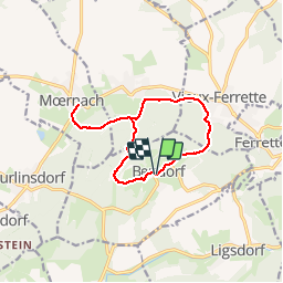

Length
11.3 km

Max alt
619 m

Uphill gradient
450 m
Km-Effort
17.3 km

Min alt
472 m

Downhill gradient
451 m
Boucle
Yes
Creation date :
2018-10-13 05:52:52.489
Updated on :
2018-10-13 05:52:52.504
3h36
Difficulty : Medium

FREE GPS app for hiking
 SityTrail
IGN / Geographical institutes
SityTrail Plus
The world is yours!
About
Trail Walking of 11.3 km to be discovered at Grand Est, Haut-Rhin, Bendorf. This trail is proposed by patrickbeyrath.
Description
Très beau chalet avec barbecue au croisement à 586m
Positioning
Country:
France
Region :
Grand Est
Department/Province :
Haut-Rhin
Municipality :
Bendorf
Location:
Unknown
Start:(Dec)
Start:(UTM)
370528 ; 5260799 (32T) N.
Comments