


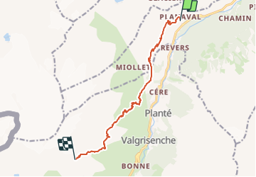
Jour 1 - Planaval - Refuge degli Angeli

i20
User


5h54
Difficulty : Very difficult

FREE GPS app for hiking
 SityTrail
IGN / Geographical institutes
SityTrail Plus
The world is yours!
About
Trail Walking of 11 km to be discovered at Aosta Valley, Unknown, Arvier. This trail is proposed by i20.
Description
Meilleure carte = IGC #102 (bleue)
Au départ, prendre le chemin #19.
A Orfeuille bifurquer à gauche.
Passer entre les parois rocheuses et arriver à Miollet.
Prendre alors le chemin n°18, pour une très longue montée jusqu'au refuge degli Angeli.
Positioning
Comments