


Munster Gunsbach

FOUCAULT
User
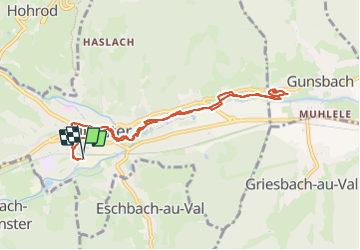

Length
8.8 km

Max alt
389 m

Uphill gradient
87 m
Km-Effort
10 km

Min alt
340 m

Downhill gradient
88 m
Boucle
Yes
Creation date :
2023-08-05 13:20:45.0
Updated on :
2023-08-05 17:01:59.305
2h27
Difficulty : Unknown

FREE GPS app for hiking
 SityTrail
IGN / Geographical institutes
SityTrail Plus
The world is yours!
About
Trail Walking of 8.8 km to be discovered at Grand Est, Haut-Rhin, Munster. This trail is proposed by FOUCAULT.
Description
Le 5 août 2023
Photos


Positioning
Country:
France
Region :
Grand Est
Department/Province :
Haut-Rhin
Municipality :
Munster
Location:
Unknown
Start:(Dec)
Start:(UTM)
360920 ; 5322161 (32U) N.
Comments