


2023-08-06_09h08m12_temp593.doc_kml_15y8_vallonbrun_01_whilh

jpb83
User
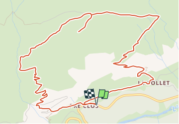

Length
8.5 km

Max alt
2294 m

Uphill gradient
621 m
Km-Effort
16.8 km

Min alt
1696 m

Downhill gradient
621 m
Boucle
Yes
Creation date :
2023-08-06 07:08:12.97
Updated on :
2023-08-06 07:10:28.115
3h48
Difficulty : Medium

FREE GPS app for hiking
 SityTrail
IGN / Geographical institutes
SityTrail Plus
The world is yours!
About
Trail Walking of 8.5 km to be discovered at Auvergne-Rhône-Alpes, Savoy, Val-Cenis. This trail is proposed by jpb83.
Positioning
Country:
France
Region :
Auvergne-Rhône-Alpes
Department/Province :
Savoy
Municipality :
Val-Cenis
Location:
Lanslevillard
Start:(Dec)
Start:(UTM)
338368 ; 5018300 (32T) N.
Comments