Trail Walking Auvillar - auvillar mirandoux - Photo
 fab0202
fab0202

User

© OpenStreetMap contributors
Length
Length
17.3 km
Max alt
Max alt
220 m
Uphill gradient
Uphill gradient
412 m
Km-Effort
Km-Effort  
23 km
Min alt
Min alt
64 m
Downhill gradient
Downhill gradient
327 m
Boucle
Boucle
No
Creation date :
2023-08-08 06:26:46.001
Updated on :
2023-08-08 13:10:12.087

(0 Reviews)

Walking
Walking
4h26
Difficulty : Medium

Scan this QR Code to open this trail in the SityTrail application

FREE GPS app for hiking

Logo SityTrail SityTrail

IGN / Geographical institutes

Download SityTrail from the App Store Download SityTrail from Google Play

Logo SityTrail SityTrail World

The world is yours!

Download SityTrail from the App Store Download SityTrail from Google Play Download SityTrail on Huawei AppGallery

About

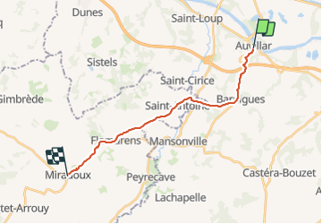
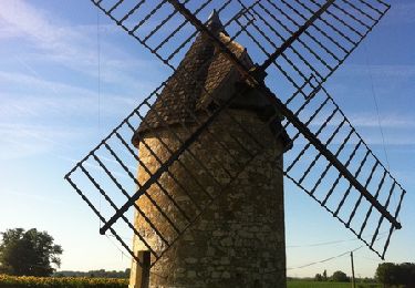
Trail Walking of 17.3 km to be discovered at Occitania, Tarn-et-Garonne, Auvillar. This trail is proposed by fab0202.

Description

belle rando entre auvillar et mirandoux en découvrant de beaux villages.

Elevation profile

Photos

Positioning

Country:
France
Region :
Occitania
Department/Province :
Tarn-et-Garonne
Municipality :
Auvillar
Location:
Unknown
Start:(UTM)
331795 ; 4881658 (31T) N.

Trails nearby

Trail Walking Saint-Antoine - CC_Velay_EC_19_St-Antoine_Lectoure_20080819 - Photo
Walking
patrickdanilo

Walking

Medium
Saint-Antoine, Occitania, Gers, France
25 km | 32 km-effort
6h 53min
No
Trail Walking Saint-Antoine - Saint Antoine - Lectoure - Chemin de Compostelle - Photo
Walking
tracegps

Walking

Very difficult
(1)
Saint-Antoine, Occitania, Gers, France
24 km | 31 km-effort
9h 34min
No
Trail Walking Saint-Loup - Saint Lou sud - Photo
Walking
jlc12

Walking

Difficult
Saint-Loup, Occitania, Tarn-et-Garonne, France
9.5 km | 12.1 km-effort
2h 31min
No
Trail Mountain bike Saint-Loup - Circuit de Cachepiot - Saint Loup - Photo
Mountain bike
tracegps

Mountain bike

Medium
Saint-Loup, Occitania, Tarn-et-Garonne, France
9.6 km | 12.5 km-effort
45min
Yes
Trail Walking Saint-Loup - Circuit de Cachepiot - Saint Loup - Photo
Walking
tracegps

Walking

Easy
Saint-Loup, Occitania, Tarn-et-Garonne, France
9.6 km | 12.5 km-effort
1h 30min
Yes
Trail Walking Auvillar - Circuit du Moulin - Auvillar les Peyrères - Photo
Walking
tracegps

Walking

Medium
Auvillar, Occitania, Tarn-et-Garonne, France
6.7 km | 8.3 km-effort
1h 30min
Yes
Trail Walking Auvillar - SityTrail - N°19  St Antoine-de-Pont-d'Arratz -- Lectoure - Photo
Walking
donda

Walking

Very difficult
Auvillar, Occitania, Tarn-et-Garonne, France
22 km | 28 km-effort
6h 23min
No
Trail Walking Auvillar - Camino 1- étape 21 du 15.08.2023 - Photo
Walking
bene_dictus77

Walking

Very difficult
Auvillar, Occitania, Tarn-et-Garonne, France
35 km | 45 km-effort
22h 58min
No
Trail Walking Auvillar - 5-Auvillar-Miradoux 18km - Photo
Walking
GUIDE
thonyc

Walking

Medium
Auvillar, Occitania, Tarn-et-Garonne, France
17.7 km | 23 km-effort
5h 13min
No


Close
My subscriptions