


L' Espigoulier sud depuis Auriol 870m+

ericberlin
User
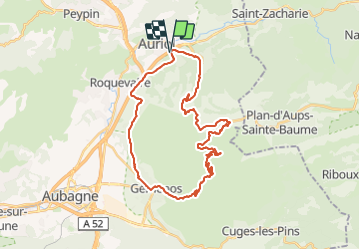

Length
36 km

Max alt
744 m

Uphill gradient
870 m
Km-Effort
47 km

Min alt
131 m

Downhill gradient
871 m
Boucle
Yes
Creation date :
2023-08-09 16:06:06.17
Updated on :
2023-08-09 16:47:36.944
2h52
Difficulty : Very difficult

FREE GPS app for hiking
 SityTrail
IGN / Geographical institutes
SityTrail Plus
The world is yours!
About
Trail Road bike of 36 km to be discovered at Provence-Alpes-Côte d'Azur, Bouches-du-Rhône, Auriol. This trail is proposed by ericberlin.
Positioning
Country:
France
Region :
Provence-Alpes-Côte d'Azur
Department/Province :
Bouches-du-Rhône
Municipality :
Auriol
Location:
Unknown
Start:(Dec)
Start:(UTM)
713847 ; 4804680 (31T) N.
Comments