


Cascade de Prelles

Nuance
User
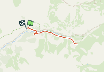

Length
6.3 km

Max alt
1656 m

Uphill gradient
191 m
Km-Effort
8.8 km

Min alt
1476 m

Downhill gradient
190 m
Boucle
Yes
Creation date :
2023-08-10 11:08:40.0
Updated on :
2023-08-10 16:53:53.184

FREE GPS app for hiking
 SityTrail
IGN / Geographical institutes
SityTrail Plus
The world is yours!
About
Trail of 6.3 km to be discovered at Provence-Alpes-Côte d'Azur, Hautes-Alpes, Champoléon. This trail is proposed by Nuance.
Positioning
Country:
France
Region :
Provence-Alpes-Côte d'Azur
Department/Province :
Hautes-Alpes
Municipality :
Champoléon
Location:
Unknown
Start:(Dec)
Start:(UTM)
284793 ; 4960189 (32T) N.
Comments