


Étang de Chabassière

martinjacque
User
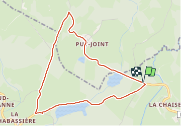

Length
4.8 km

Max alt
576 m

Uphill gradient
58 m
Km-Effort
5.5 km

Min alt
542 m

Downhill gradient
58 m
Boucle
Yes
Creation date :
2023-08-13 08:04:56.917
Updated on :
2023-08-13 10:06:11.907
2h00
Difficulty : Very easy

FREE GPS app for hiking
 SityTrail
IGN / Geographical institutes
SityTrail Plus
The world is yours!
About
Trail Walking of 4.8 km to be discovered at New Aquitaine, Creuse, Vallière. This trail is proposed by martinjacque.
Description
très belle balade pas difficile.
Positioning
Country:
France
Region :
New Aquitaine
Department/Province :
Creuse
Municipality :
Vallière
Location:
Unknown
Start:(Dec)
Start:(UTM)
422929 ; 5084595 (31T) N.
Comments