Trail Walking Malauzat - depuis de marcoing - Photo
 jeriom
jeriom

User

© OpenStreetMap contributors
Length
Length
7.5 km
Max alt
Max alt
557 m
Uphill gradient
Uphill gradient
196 m
Km-Effort
Km-Effort  
10 km
Min alt
Min alt
392 m
Downhill gradient
Downhill gradient
173 m
Boucle
Boucle
No
Creation date :
2023-08-13 08:25:45.001
Updated on :
2023-08-13 12:39:39.226

(0 Reviews)

Walking
Walking
2h49
Difficulty : Easy

Scan this QR Code to open this trail in the SityTrail application

FREE GPS app for hiking

Logo SityTrail SityTrail

IGN / Geographical institutes

Download SityTrail from the App Store Download SityTrail from Google Play

Logo SityTrail SityTrail World

The world is yours!

Download SityTrail from the App Store Download SityTrail from Google Play Download SityTrail on Huawei AppGallery

About

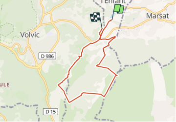
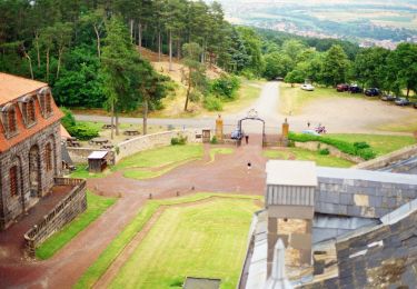
Trail Walking of 7.5 km to be discovered at Auvergne-Rhône-Alpes, Puy-de-Dôme, Malauzat. This trail is proposed by jeriom.

Description

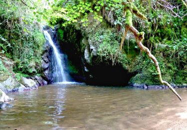
belle promenade autour du Puy de Marcoin. La majorité du sentier est sur un gr. le parcours est ombragé. quelques points de vue intéressants. Le sommet du modeste puiy de marcoin est quant à lui carrément horrible puisqu'il est constitué d'un château d'eau rempli de graffiti. heureusement il passe très vite.

Elevation profile

Photos

Positioning

Country:
France
Region :
Auvergne-Rhône-Alpes
Department/Province :
Puy-de-Dôme
Municipality :
Malauzat
Location:
Unknown
Start:(UTM)
505163 ; 5080294 (31T) N.

Trails nearby

Trail Walking Chanat-la-Mouteyre - Chanat_Trois_Villages - Photo
Walking
GUIDE
jagarnier

Walking

Medium
(1)
Chanat-la-Mouteyre, Auvergne-Rhône-Alpes, Puy-de-Dôme, France
10 km | 14 km-effort
3h 0min
Yes
Trail Walking Enval - Enval_Gorges - Photo
Walking
GUIDE
jagarnier

Walking

Medium
(1)
Enval, Auvergne-Rhône-Alpes, Puy-de-Dôme, France
9.1 km | 13.2 km-effort
2h 45min
Yes
Trail Walking Châtel-Guyon - Chazeron sans souci - Photo
Walking
Gegetop

Walking

Easy
(1)
Châtel-Guyon, Auvergne-Rhône-Alpes, Puy-de-Dôme, France
6.6 km | 9.7 km-effort
1h 45min
Yes
Trail Walking Châtel-Guyon - Boucle de Rochepradière en passant par Douhady - Photo
Walking
Gegetop

Walking

Easy
(1)
Châtel-Guyon, Auvergne-Rhône-Alpes, Puy-de-Dôme, France
6.7 km | 9.7 km-effort
2h 6min
Yes
Trail Walking Châtel-Guyon - Le tour de Montaclier - Saint Hippolyte - Photo
Walking
tracegps

Walking

Difficult
(1)
Châtel-Guyon, Auvergne-Rhône-Alpes, Puy-de-Dôme, France
14 km | 19.6 km-effort
3h 30min
Yes
Trail Mountain bike Volvic - Tour du Puy de Dôme en VTT - Photo
Mountain bike
tracegps

Mountain bike

Very difficult
(1)
Volvic, Auvergne-Rhône-Alpes, Puy-de-Dôme, France
62 km | 85 km-effort
5h 30min
Yes
Trail Walking Volvic - Les sources de Volvic - Photo
Walking
tracegps

Walking

Medium
(2)
Volvic, Auvergne-Rhône-Alpes, Puy-de-Dôme, France
10.9 km | 14.3 km-effort
3h 0min
Yes
Trail Walking Volvic - Egaules (près de Luzet) - Photo
Walking
tracegps

Walking

Difficult
(1)
Volvic, Auvergne-Rhône-Alpes, Puy-de-Dôme, France
8.8 km | 10.8 km-effort
2h 45min
Yes
Trail On foot Châtel-Guyon - La Vallée du Sans-Souci - Photo
On foot
PRO

On foot

Easy
Châtel-Guyon, Auvergne-Rhône-Alpes, Puy-de-Dôme, France
4.4 km | 6.5 km-effort
1h 28min
Yes


Close
My subscriptions