


Kruth bockloch

philvor
User
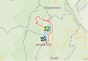

Length
10.8 km

Max alt
957 m

Uphill gradient
476 m
Km-Effort
17.3 km

Min alt
523 m

Downhill gradient
511 m
Boucle
No
Creation date :
2023-08-13 09:08:14.0
Updated on :
2023-08-13 12:52:39.892
3h42
Difficulty : Medium

FREE GPS app for hiking
 SityTrail
IGN / Geographical institutes
SityTrail Plus
The world is yours!
About
Trail Walking of 10.8 km to be discovered at Grand Est, Haut-Rhin, Kruth. This trail is proposed by philvor.
Description
Kruth du camping au Hinter bockloch plus tour du lac
Positioning
Country:
France
Region :
Grand Est
Department/Province :
Haut-Rhin
Municipality :
Kruth
Location:
Unknown
Start:(Dec)
Start:(UTM)
346973 ; 5313095 (32T) N.
Comments