


Torons de Terminion

Kilroy06
User
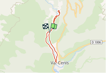

Length
6.1 km

Max alt
1399 m

Uphill gradient
119 m
Km-Effort
7.7 km

Min alt
1289 m

Downhill gradient
119 m
Boucle
Yes
Creation date :
2023-08-15 07:34:47.0
Updated on :
2023-08-15 09:29:00.552
1h53
Difficulty : Medium

FREE GPS app for hiking
 SityTrail
IGN / Geographical institutes
SityTrail Plus
The world is yours!
About
Trail Walking of 6.1 km to be discovered at Auvergne-Rhône-Alpes, Savoy, Val-Cenis. This trail is proposed by Kilroy06.
Positioning
Country:
France
Region :
Auvergne-Rhône-Alpes
Department/Province :
Savoy
Municipality :
Val-Cenis
Location:
Termignon
Start:(Dec)
Start:(UTM)
328370 ; 5017419 (32T) N.
Comments