


Roc de Sainte-Julie

houbart
User
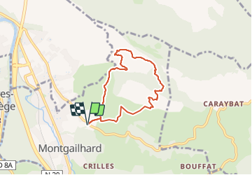

Length
6.5 km

Max alt
864 m

Uphill gradient
415 m
Km-Effort
12 km

Min alt
457 m

Downhill gradient
415 m
Boucle
Yes
Creation date :
2023-08-15 08:08:15.143
Updated on :
2023-10-05 09:27:04.247
2h44
Difficulty : Difficult

FREE GPS app for hiking
 SityTrail
IGN / Geographical institutes
SityTrail Plus
The world is yours!
About
Trail Walking of 6.5 km to be discovered at Occitania, Ariège, Montgaillard. This trail is proposed by houbart.
Photos


Positioning
Country:
France
Region :
Occitania
Department/Province :
Ariège
Municipality :
Montgaillard
Location:
Unknown
Start:(Dec)
Start:(UTM)
389066 ; 4754842 (31T) N.
Comments