


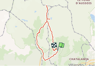
Refuge de l'Orgère/ col de Chavière

geoffrayLayeux
User

Length
15.7 km

Max alt
2790 m

Uphill gradient
1069 m
Km-Effort
30 km

Min alt
1788 m

Downhill gradient
1080 m
Boucle
Yes
Creation date :
2023-08-15 15:13:47.532
Updated on :
2023-08-15 15:14:52.061
6h49
Difficulty : Very difficult

FREE GPS app for hiking
 SityTrail
IGN / Geographical institutes
SityTrail Plus
The world is yours!
About
Trail Walking of 15.7 km to be discovered at Auvergne-Rhône-Alpes, Savoy, Villarodin-Bourget. This trail is proposed by geoffrayLayeux.
Positioning
Country:
France
Region :
Auvergne-Rhône-Alpes
Department/Province :
Savoy
Municipality :
Villarodin-Bourget
Location:
Unknown
Start:(Dec)
Start:(UTM)
317289 ; 5011010 (32T) N.
Comments