


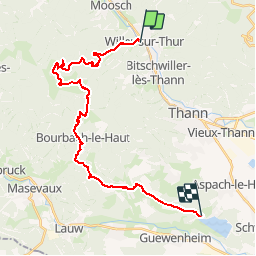
Circuit Sundgau - Willer sur Thur - Michelbach

Tourisme Equestre Alsace
Promouvoir le Tourisme Equestre en Alsace GUIDE+

Length
26 km

Max alt
1162 m

Uphill gradient
1047 m
Km-Effort
40 km

Min alt
343 m

Downhill gradient
1069 m
Boucle
No
Creation date :
2015-01-15 00:00:00.0
Updated on :
2019-01-07 11:39:39.974
4h47
Difficulty : Difficult

FREE GPS app for hiking
 SityTrail
IGN / Geographical institutes
SityTrail Plus
The world is yours!
About
Trail Horseback riding of 26 km to be discovered at Grand Est, Haut-Rhin, Willer-sur-Thur. This trail is proposed by Tourisme Equestre Alsace.
Photos


Positioning
Country:
France
Region :
Grand Est
Department/Province :
Haut-Rhin
Municipality :
Willer-sur-Thur
Location:
Unknown
Start:(Dec)
Start:(UTM)
355529 ; 5300581 (32T) N.
Comments