


deux lacs col de la croix de fer

Fredosolo
User
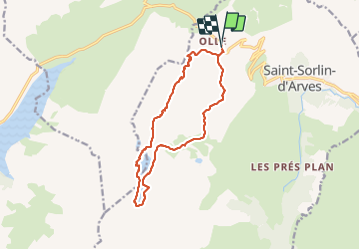

Length
14.3 km

Max alt
2537 m

Uphill gradient
656 m
Km-Effort
23 km

Min alt
2055 m

Downhill gradient
659 m
Boucle
Yes
Creation date :
2023-08-10 09:06:27.719
Updated on :
2023-08-16 17:48:22.191
5h05
Difficulty : Very difficult

FREE GPS app for hiking
 SityTrail
IGN / Geographical institutes
SityTrail Plus
The world is yours!
About
Trail Walking of 14.3 km to be discovered at Auvergne-Rhône-Alpes, Savoy, Saint-Sorlin-d'Arves. This trail is proposed by Fredosolo.
Positioning
Country:
France
Region :
Auvergne-Rhône-Alpes
Department/Province :
Savoy
Municipality :
Saint-Sorlin-d'Arves
Location:
Unknown
Start:(Dec)
Start:(UTM)
280364 ; 5012273 (32T) N.
Comments