


Eymoutiers vallée de la Vienne

taguette
User
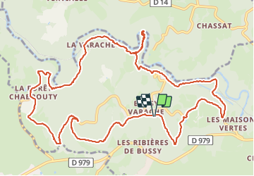

Length
15.6 km

Max alt
550 m

Uphill gradient
447 m
Km-Effort
22 km

Min alt
322 m

Downhill gradient
447 m
Boucle
Yes
Creation date :
2023-08-17 06:21:31.886
Updated on :
2023-08-17 09:57:35.615
3h33
Difficulty : Medium

FREE GPS app for hiking
 SityTrail
IGN / Geographical institutes
SityTrail Plus
The world is yours!
About
Trail Walking of 15.6 km to be discovered at New Aquitaine, Haute-Vienne, Eymoutiers. This trail is proposed by taguette.
Positioning
Country:
France
Region :
New Aquitaine
Department/Province :
Haute-Vienne
Municipality :
Eymoutiers
Location:
Unknown
Start:(Dec)
Start:(UTM)
399172 ; 5066350 (31T) N.
Comments