


Le tour du Mt Ventoux Routes et sentiers depuis le chalet Reynard

julu
User
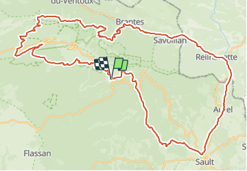

Length
62 km

Max alt
1599 m

Uphill gradient
1921 m
Km-Effort
88 km

Min alt
460 m

Downhill gradient
1913 m
Boucle
Yes
Creation date :
2023-08-18 05:35:41.288
Updated on :
2023-08-25 06:19:26.397
5h36
Difficulty : Very difficult

FREE GPS app for hiking
 SityTrail
IGN / Geographical institutes
SityTrail Plus
The world is yours!
About
Trail Mountain bike of 62 km to be discovered at Provence-Alpes-Côte d'Azur, Vaucluse, Bédoin. This trail is proposed by julu.
Positioning
Country:
France
Region :
Provence-Alpes-Côte d'Azur
Department/Province :
Vaucluse
Municipality :
Bédoin
Location:
Unknown
Start:(Dec)
Start:(UTM)
685189 ; 4891278 (31T) N.
Comments