


Lestelle-Bétharram G4 2023

LouisROGER
User GUIDE

Length
11.3 km

Max alt
471 m

Uphill gradient
222 m
Km-Effort
14.3 km

Min alt
295 m

Downhill gradient
222 m
Boucle
Yes
Creation date :
2023-08-18 07:46:30.782
Updated on :
2023-08-18 12:24:27.666
4h37
Difficulty : Difficult

FREE GPS app for hiking
 SityTrail
IGN / Geographical institutes
SityTrail Plus
The world is yours!
About
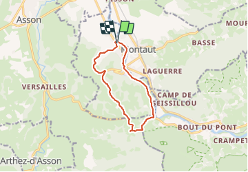
Trail Walking of 11.3 km to be discovered at New Aquitaine, Pyrénées-Atlantiques, Lestelle-Bétharram. This trail is proposed by LouisROGER.
Photos


Positioning
Country:
France
Region :
New Aquitaine
Department/Province :
Pyrénées-Atlantiques
Municipality :
Lestelle-Bétharram
Location:
Unknown
Start:(Dec)
Start:(UTM)
726898 ; 4779271 (30T) N.
Comments